Featured

Verulamium Museum and Park

Overall Impact **** 4 stars Museum with excellent artefacts wonderfully displayed with thematic exhibits of Roman civil life

Roman Features ***** 5 stars Mosaics are many of the finest in Britannia, plus a lead coffin, wall paintings, a late antique horde of solidi and much more

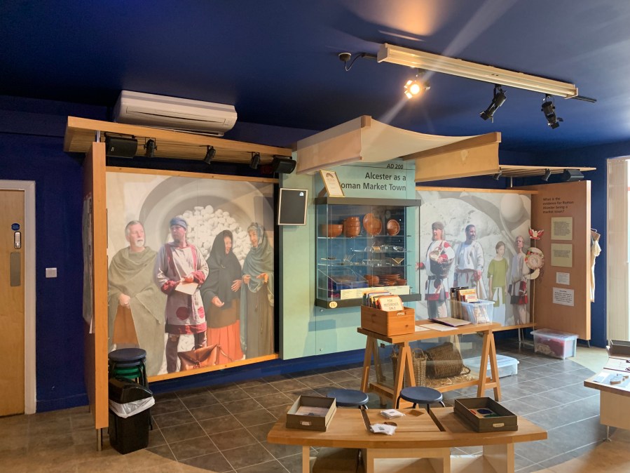
Display **** 4 stars Thematic rooms work hard to bring the exhibits to life and explain how the inhabitants of Verulamium lived

Reconstruction **** 4 stars The restored rooms with wall paintings are superb

Access **** 4 stars Modern museum with good access. Car park handy for both Museum and Park.

Atmosphere *** 3 stars The Museum and Park are both branded Verulamium, but it is quite hard to visualise what the Roman city would have looked like: maybe some more illustrative boards around the park would help?

Other ***** 5 stars We reckon this is the second-best Roman museum in Britannia – and the best museum of civil life of the period. (We still have to give Vindolanda Museum the top spot!)

We were inspired by publishing our Brading Villa blog recently and, since the sun was shining, we thought we should have look at another Roman site.  (Our first idea was Silchester and the finds in Reading Museum’s Roman galleries but, alas, Reading Museum is not open on Sundays. )

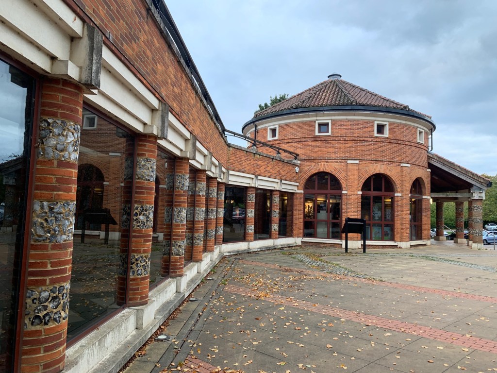
So our choice fell on Verulamium Museum and Park at St Albans.  Thirty years ago we used to live in ‘Snorbans’ and a fine and distinctive city it is. Since then the old Museum – already good – has been refurbished, given a circular Roman-inspired entrance and had new galleries added.  Thank you National Lottery Fund, once again!

Is this the best dedicated Roman museum in Britannia?  

Original wall paintings restored in a reconstructed room

We think so – at least as far as civilian life is concerned (the latest incarnation of Vindolanda is simply stunning, obviously with a more military focus). Verulamium Museum sets out to be the museum of everyday Roman life and with dedicated galleries on trade and industry, life and death, and much else, it succeeds.  Verulamium was the 3rd largest Roman city in Britannia (presumably after Londinium and Camulodunum?) and the quality of the finds excavated by Mortimer and Tessa Wheeler in the 30s and by Shepherd Frere in the 70s are tremendous.  This thematic approach is quite commonplace these days but it’s carried through here with confidence and illustrated with some remarkable finds. Our favourites include:

1). The lead coffin from around 200AD from King Harry Lane with its scallop shell decoration and a rather witty video by the deceased (here wittily christened Postumus) describing his life and subsequent rediscovery. 

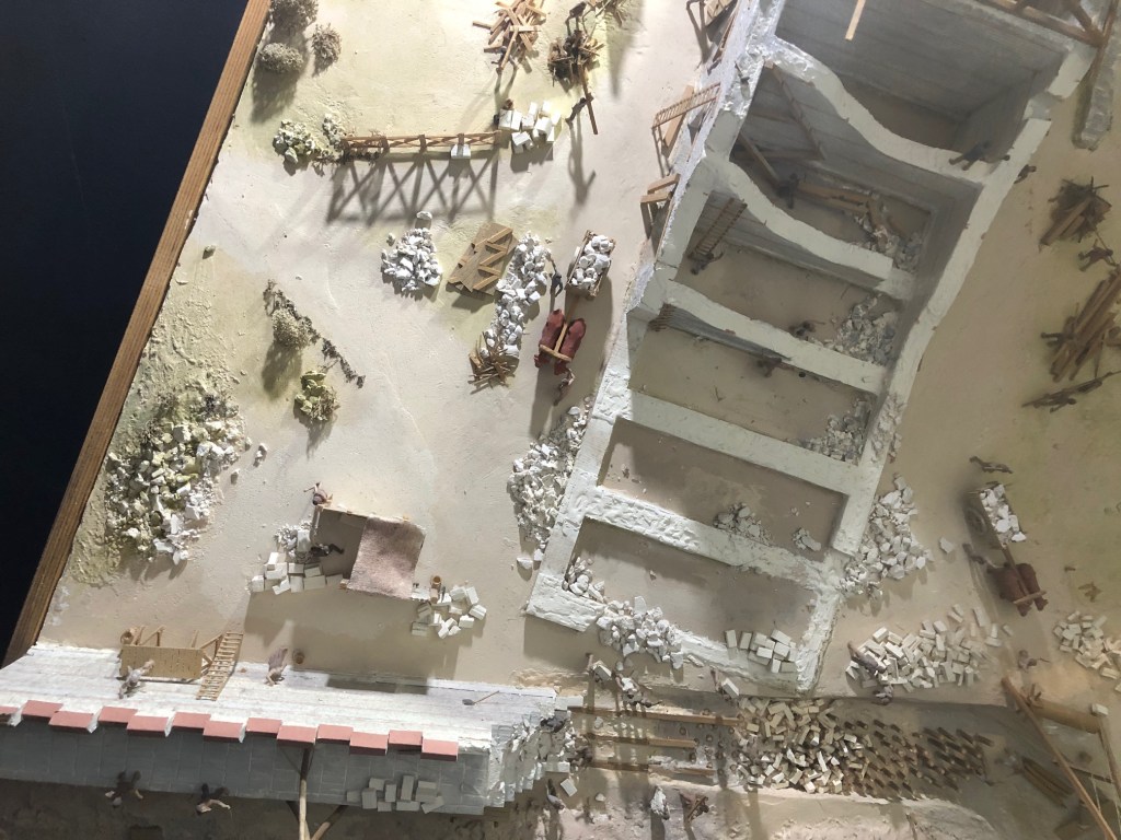
2).  The display of carpenters’ tools left behind while escaping the great fire of Verulamium in 180AD.

3).   A tiny statuette of Mercury with his ram, tortoise and cockerel, and wearing a tiny torc.  

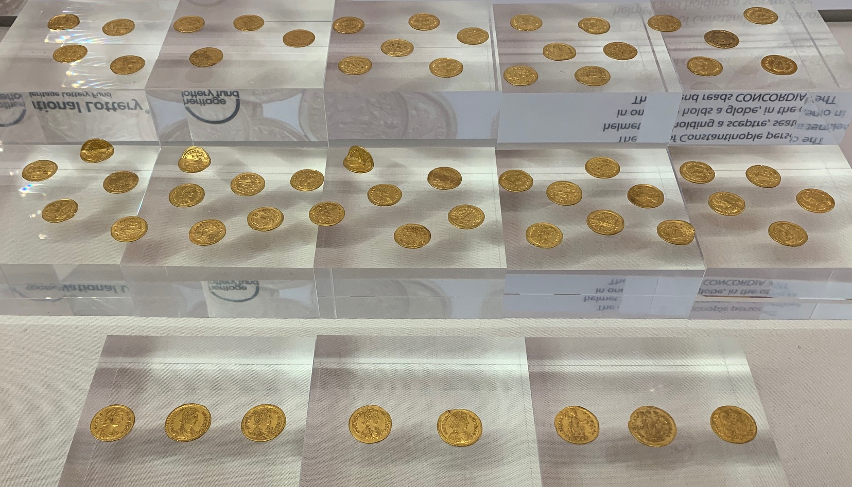
4).  The remarkable Sandridge Hoard of 156 gold solidi, found by a fortunate metal detectorist testing out his new equipment.

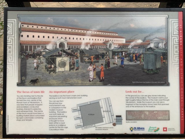
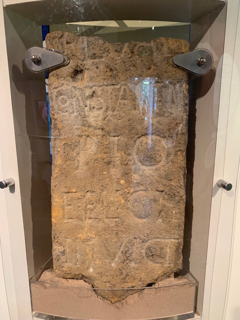
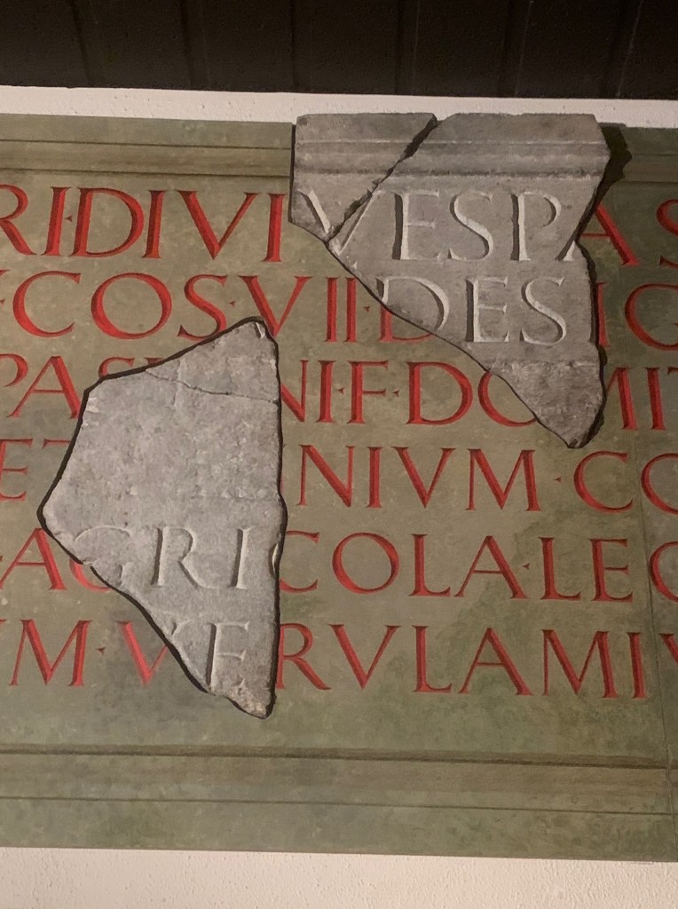
5).  The inscription from the new Forum built in the reign of Titus which (most probably) mentions the Governor Julius Agricola, developing the pacified parts of the Province just as Tacitus describes. 

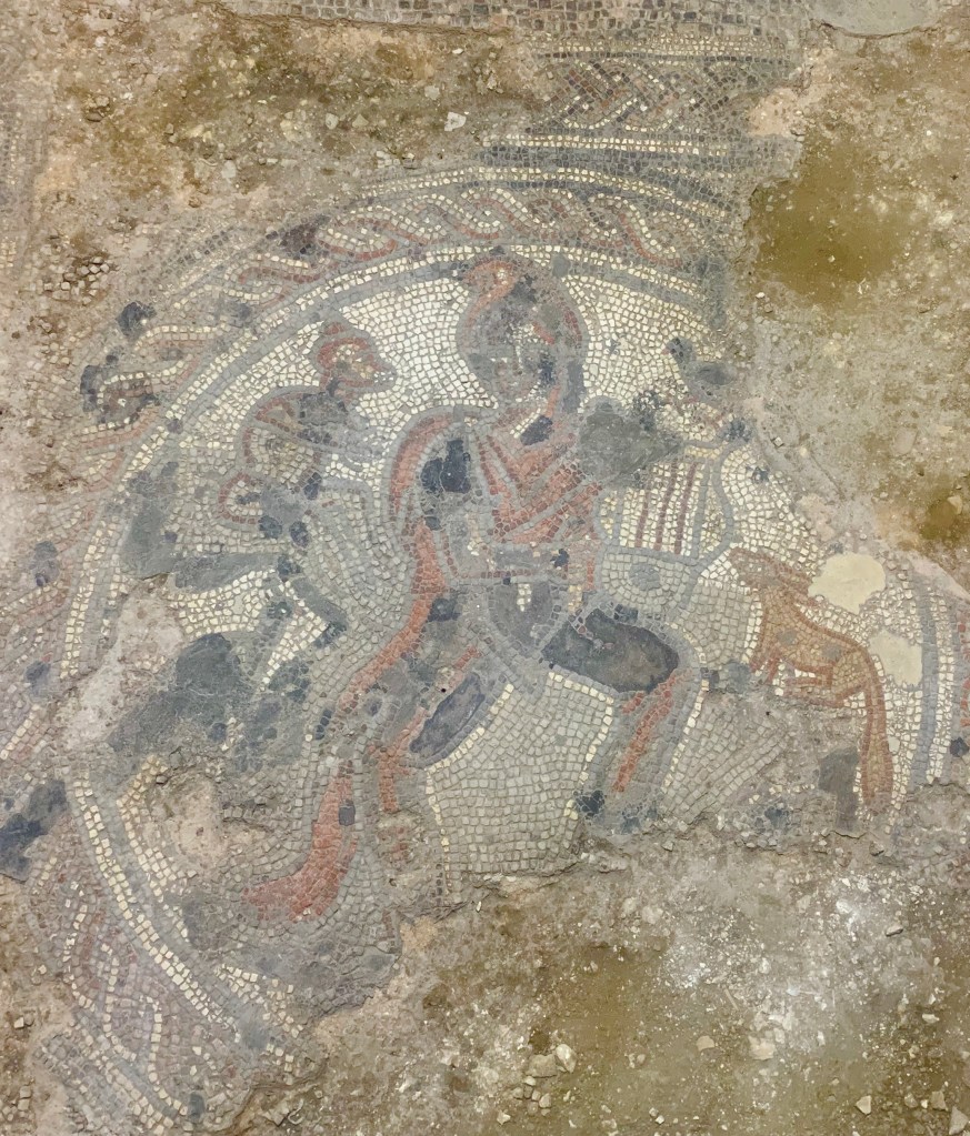
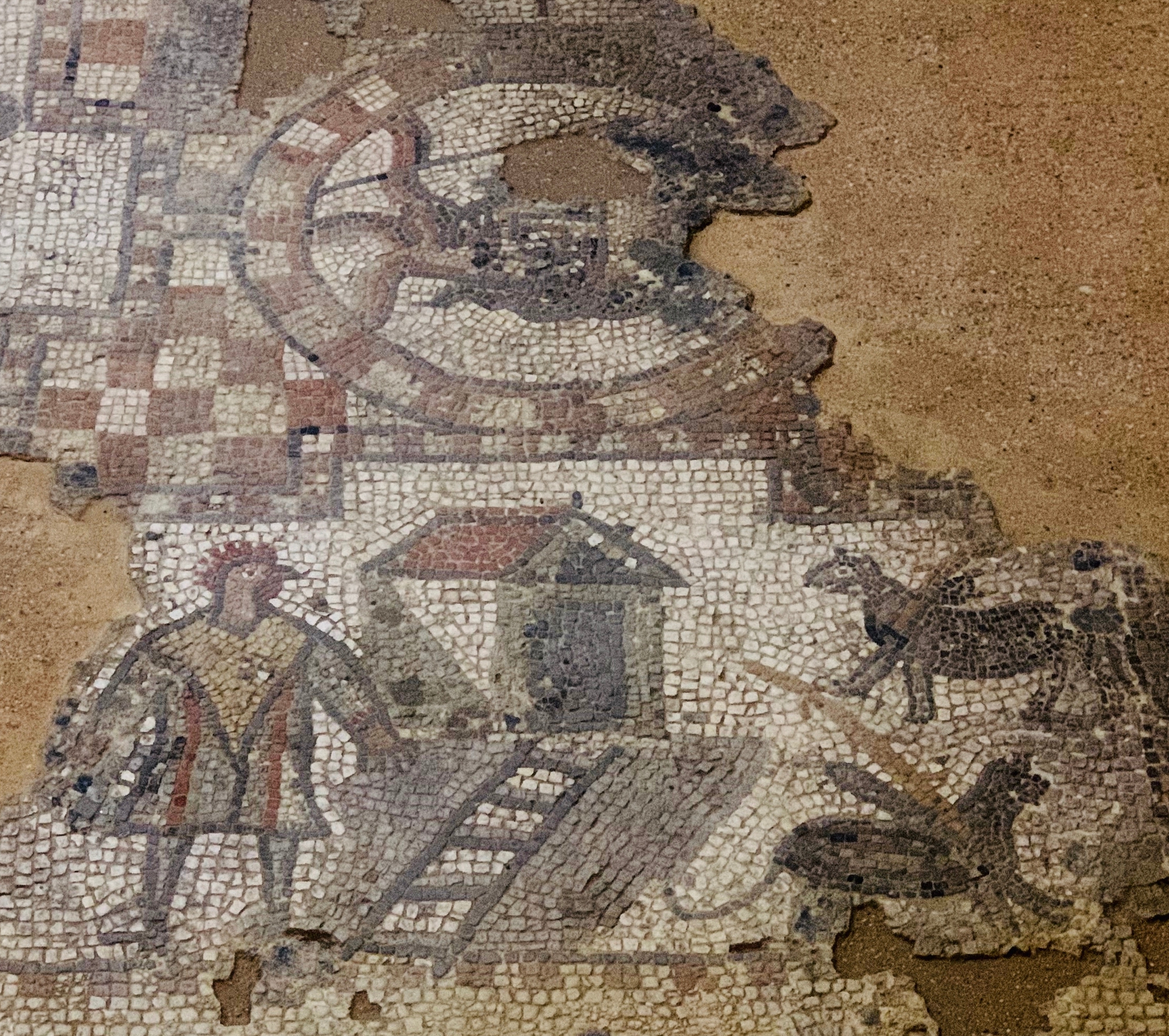
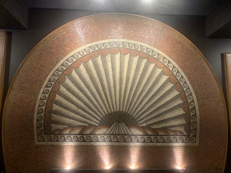
This is before we have mentioned the real star exhibits of the Museum – the mosaics and the wall paintings from the fine mansions of the Roman city. There are 3 mosaics in the main museum hall – a shell image in the centre, with a horned figure (possibly identified with Cernunnos, a woodland god) to the right, and a lion and stag to the left.  

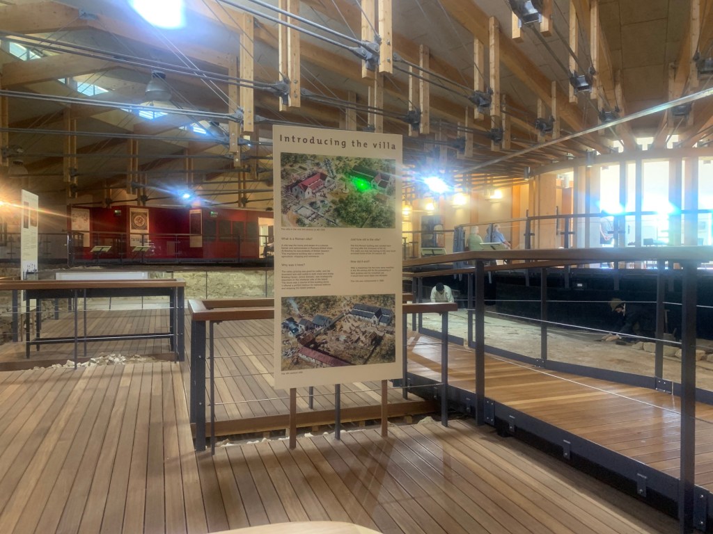
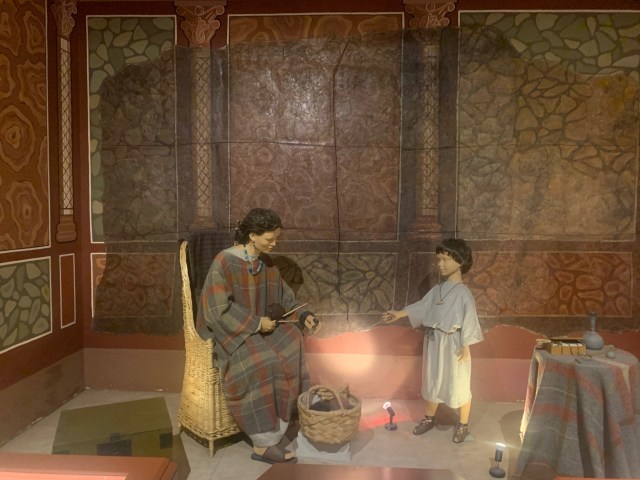
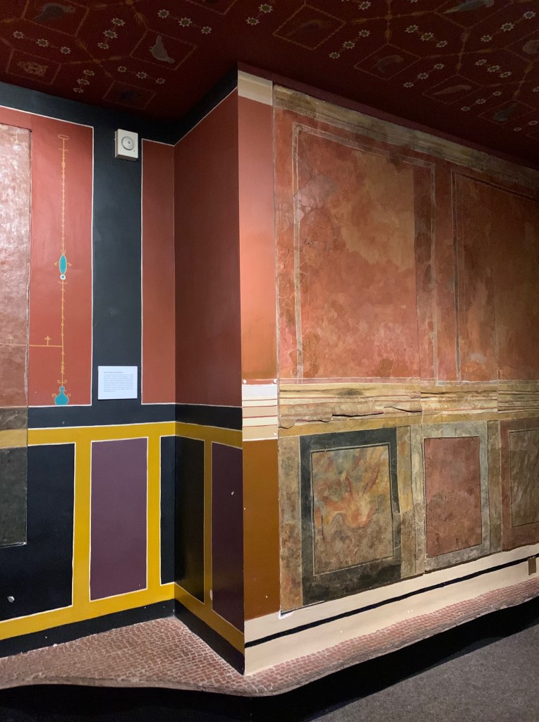
The wall and ceiling paintings have been imaginatively displayed in reconstructed rooms, with the missing plaster and colours filled in. The overall effect is to give a real feeling of what a grand provincial mansion looked like.  What  strikes you are both the striking colours and compositions and the relative crudity of the actual workmanship – the representation of marble, for instance, is not at all convincing!  

The first galleries cover pre-Roman Verulamion: the area was a centre of the Catuvellauni, who under Cassivellaunus led the resistance to Caesar in 55BC. Later the Catuvellauni were ruled by Tasciovanus and by 10AD Cunobelinus was in charge. He conquered the Trinovantes and moved his capital to the Colchester area, but continued to rule Verulamion. Whilst Cunobelinus successfully avoided Roman intervention, under his sons Caractacus and Togidubnus in 43 AD the kingdom was invaded by Claudius.

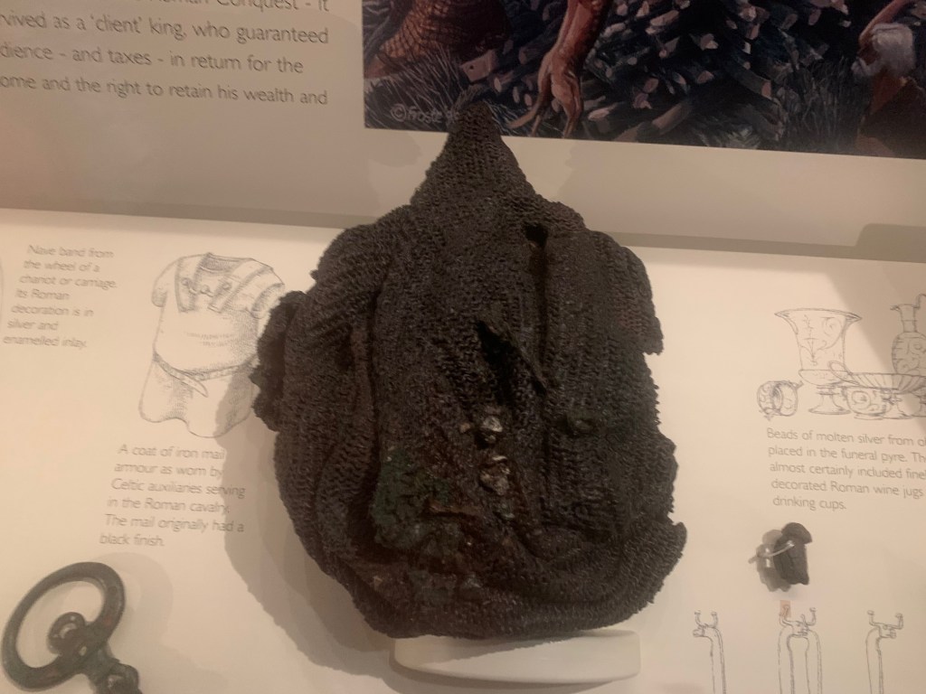
After the Roman conquest the Trinovantes were conquered and a Colonia of legionaries planted at Camulodunum. However, the Catuvellauni become a client kingdom, possibly under the leadership of Adminius, another son of Cunobelinus who had fled to Rome before the Conquest. The burial from Folly Lane dated to AD50 appears to be the leader of the Catuvellauni under Roman domination. The rich burial features a chariot, an iron mail coat (above) and quantities of silver, all placed on the funeral pyre.

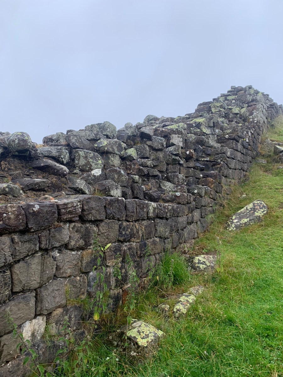
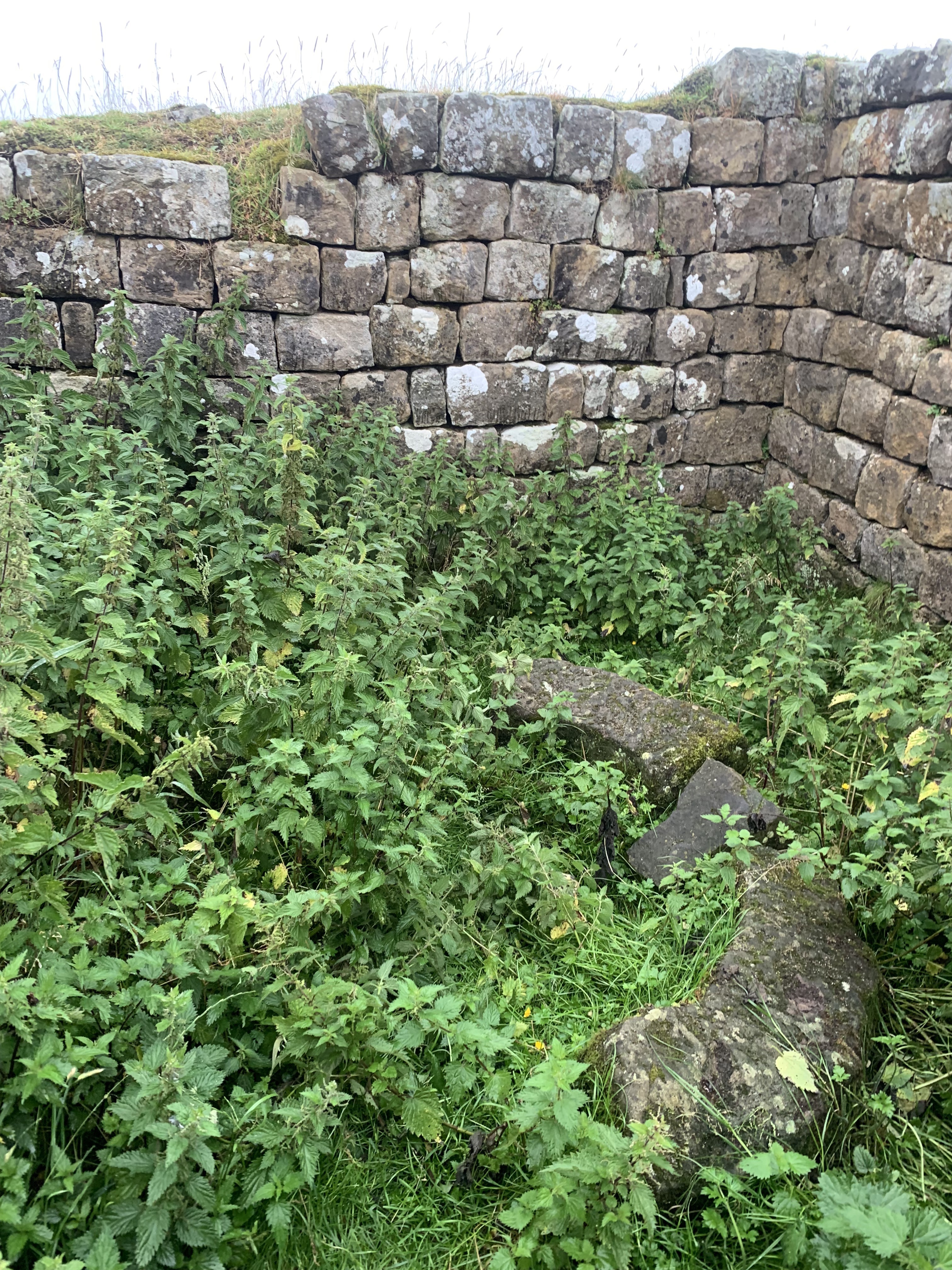
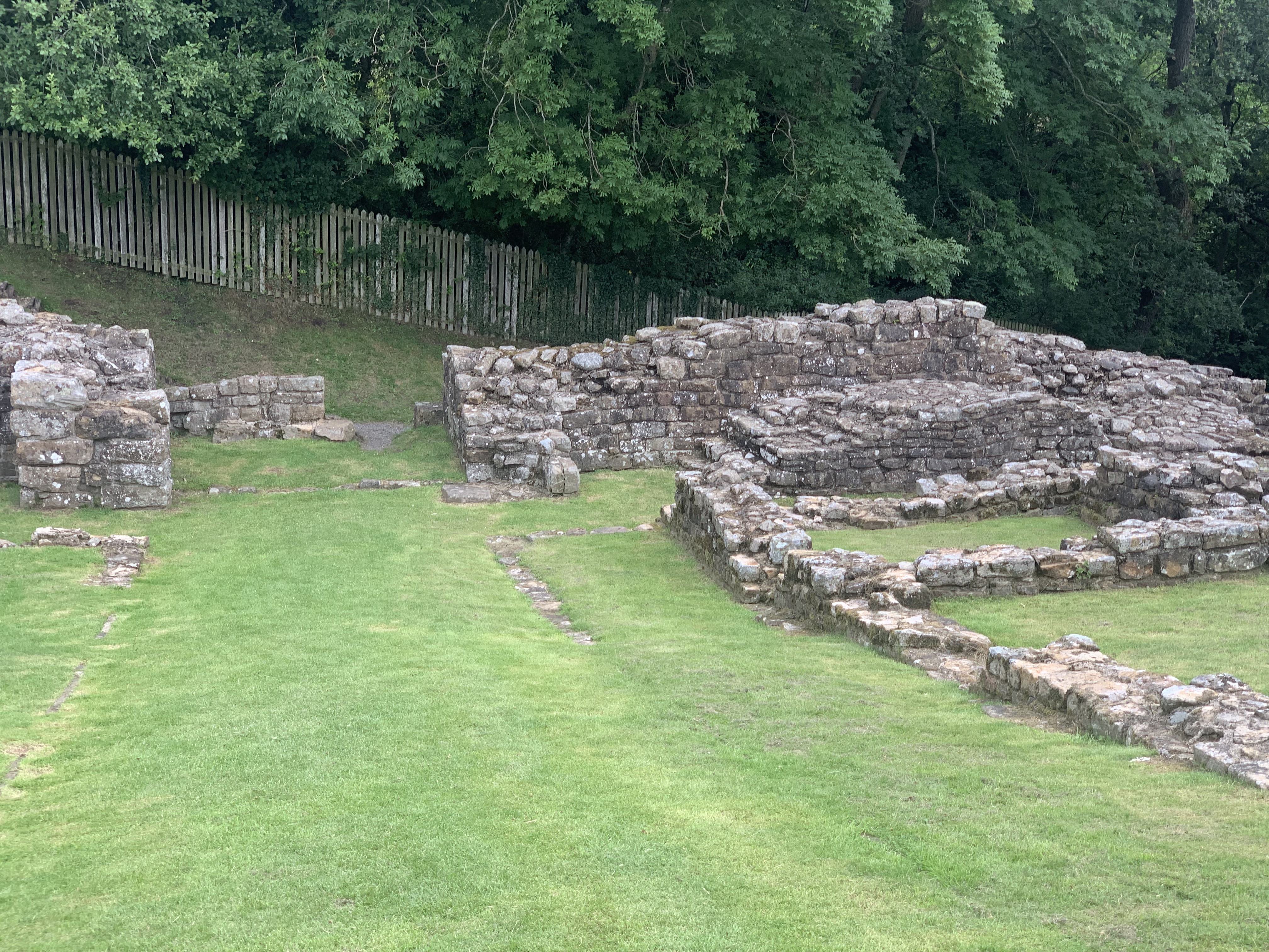
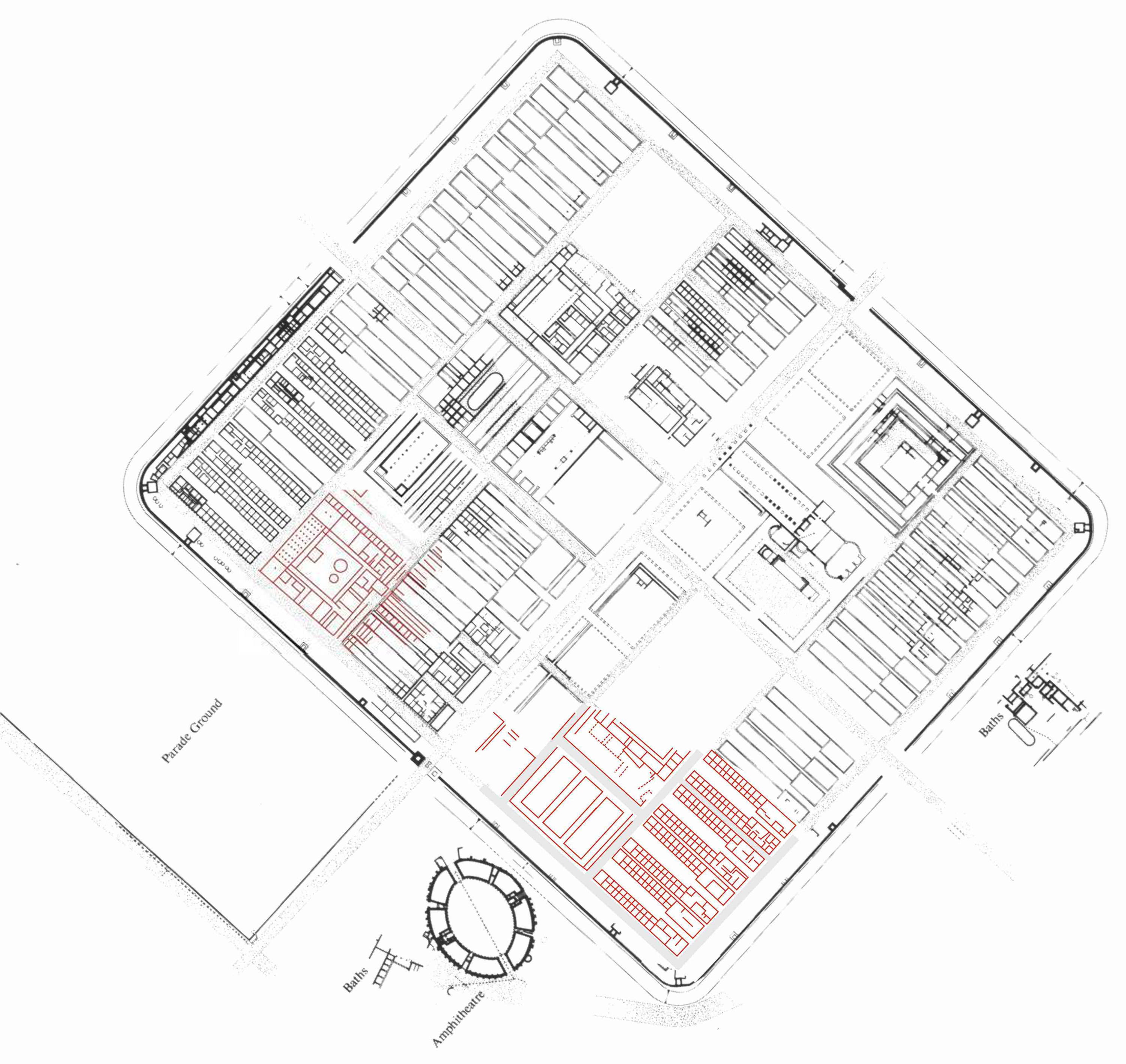
The Museum sits close to the site of the vast Forum of Verulamium, on which the Church is built. So all round you are the hidden remains of the City. There are three things to see in the Park – the mosaic from one of the town houses, the battered remains of the City Walls and the site of the London Gate.

Reconstruction drawing of the vast Verulamium Forum

Featured

Brading Villa IoW

Overall Impact *** 3 stars, good – if damaged – mosaics under an ultra-modern cover building, with a rather nice café attached!

Roman Features **** 4 stars, there are several mosaics in situ, unusually for a British site, so they deserve to be seen.

Reconstruction None

Access **** 4 stars, once reached (local roads narrow), very good with disabled access.

Atmosphere ** 2 stars, it’s quite hard to get the feel of the villa, although the computer reconstructions are good.

Other ***** 5 stars, keen volunteers. Any site that’s maintained on local enthusiasm and acts as a community hub deserves all our encouragement!

We were spending the night in Winchester and were looking forward to following in Vespasian’s caligae through the hill forts of the Durotriges the next day, when we happened across a tweet from @bradingromanvilla.org.uk Since we had never visited Brading Villa and it claimed to have some of the best mosaics in the country (and furthermore one of us had never crossed the Solent), we decided on the spur of the moment to visit it.

We recommend you cross the Solent too, if you have the chance…

Orpheus charming the animals – alas, much damaged.

If we are really honest, the mosaics are good but they suffered, first, from the occupation of squatters in the villa in the C5th who put in a corn-dryer in part of the floor, then started fires in the wooden structure. Then, following discovery of the mosaics were left in the open with only temporary covers by the Victorian owners for 10 years. Finally, flooding in January 2004 deposited water from the fields above the villa on to the mosaics. The water. being fertiliser impregnated, alas bleached out much of the remaining colour from the mosaics.

Detail of a Seasons Mosaic with Winter wrapped up against the cold.

None of this should deter a visit. Brading has been run by a Charitable Trust since 1994 and they have, after the disaster of the floods, raised funds to erect a startlingly excellent environmentally-sensitive cover building, complete with a strong room for travelling exhibitions – the British Museum’s Hoards exhibition was on display when were were there. There are up-to-the-moment digital reconstructions of the local landscape and how a hypocaust works. There are games for child visitors and much explanation. (There are some idiosyncratic assertions in the displays – for instance on the ‘degeneracy’ of the C4th Army. ) All good fun.

Nice reconstruction of the Villa at its height in the C3rd with both the main Western Building in occupation and the North Building with barn and baths.

The Villa was discovered in 1870 by the local farmer, Mr Munns. A local retired army officer, Captain Thorp, was looking for antiquities and he realised what this was, and he and Munns uncovered the famous ‘Gallus Mosaic’. The local landowners, the Oglanders, purchased the whole site and got in some London archaeologists to excavate the rest of the villa – none too carefully, it appears: Captain Thorp had been keeping better records!

The star attraction the Gallus mosaic. There are various explanations that this is a Gladiator called ‘Gallus’, or a satire on C4th politics and the Eastern Emperor Gallus (unlikely).

The Villa is in three parts which, following recent re-excavations by Oxford University, have been interpreted as three successive stages in its development, reflecting the social prestige of its inhabitants. The enthusiastic and knowledgeable volunteer curator explained to us that, on the conquest of the Isle of Wight (Vectis) the leaders of the Iron Age village which was situated just east of the villa site, moved and built a villa on the South Range in the second half of the C1st. Then, around AD200 the North Range was added with a baths suite. Finally, the luxurious West Range dates from AD300 and was a final upgrade to the living conditions, complete with mosaics with classical references.

Since the disastrous flood, the site has been purchased by a Charitable Trust who operates the site in an enterprising fashion. There is a well-stocked gift shop ranging from the usual Roman souvenirs up to replica mosaics, should you fancy upgrading your dining room or bathroom! They also have a large café/restaurant which was doing a roaring trade in Sunday lunches. And on Saturday nights, mainstream movies are screened there – good for them. The cover building is a modern architectural masterpiece designed to touch the site as little as possible and spans the area spectacularly. Finally, the Trust has built a secure gallery so that visiting exhibitions can be accommodated.

Iron Age torcs from a Norfolk hoard, visiting Brading when we were there.
The modern cover building.
Featured

Roman Alcester Heritage Centre

Overall Impact ** 2 stars – rather nice local museum with some good exhibits from local digs well displayed.

Roman Features Nothing Roman survives above ground in Alcester!

Reconstructions None

Access *** 3 stars – museum is within the new Alcester library, with helpful volunteers, and you can park at the nearby Waitrose

Atmosphere ** 2 stars – you need to use your imagination

Other *** 3 stars – it’s well set up for children’s activities, and two audiovisuals bring the finds and the market to life.

Looking for Roman interest before seeing Shakespeare’s King John at the RSC at Stratford-upon-Avon, we googled ‘Roman Warwickshire’ and found the Roman Alcester Heritage Centre. This is a fantastic example of a local community enthusiastically embracing its Roman past, with the newly-built town library incorporating a room dedicated to exhibiting the finds from the Roman ‘small town’ of Alauna, modern Alcester.

Elements of military harness.

During the conquest period it is thought there was a fort on the hill with views dominating the valley of the River Arrow, which then moved down into the valley before being evacuated around AD75, no doubt to move north or west for the Flavian conquests. There are some fine military finds exhibited in the cases in the museum. The forts were at the crossroads of the Roman north-south and east-west road grid (the so-called Ryknild Way and the Salt Way from the Fosse Way to Droitwich).

Impressive but heavily weathered statue

As the area became part of the civilian zone and of the northern civitas of the Dobunni people, so Alcester became a flourishing town of some scale. The finds suggest a degree of prosperity with finds of fine imported Samian tableware, simple mosiacs and wall paintings, and a possible mansio. Alauna was clearly the market for the area.

A noteworthy local find was burnt some asparagus seeds, reportedly the earliest evidence of its cultivation in Britain!

Milestone with inscription:
FL VAL/CONSTANTINO/PIO/FELIC/INVICT/AUG
‘For Flavius Valerius Contantinus the dutiful fortunate and unconquered Emperor’

There is a fine milestone dating from Constantine the Great’s reign, and in the 4th Century AD, as the world became more dangerous, a wall was built around the core of the settlement on the original fort hill. The walls involved demolishing a granary and covered less than half of the original town’s full extent.

Model in the museum depicting the demolition of a granary and construction of the defensive wall mid C3rd

Reflections on the Hadrian’s Wall Pilgrimage 2019

“There are things we know that we know. There are known unknowns. That is to say there are things that we now know we don’t know. But there are also unknown unknowns. There are things we do not know we don’t know.”

On our final coach journey of the Pilgrimage, this (at the time much derided) quote from Donald Rumsfeld was used to sum up the current state of knowledge about Hadrian’s Wall. We certainly left with more unanswered questions than we had started with – and maybe this was the objective of our excellent guides?

The Pilgrimage was enjoyable, entertaining and educational – and also very good exercise, especially the final steep climb to Mucklebank Turret (T44b). Our heartfelt thanks go to the Chief Pilgrim, David Breeze, and to everyone else who made this Pilgrimage possible. 

Here are 3 of the many questions and new ideas to us that stuck in our memories afterwards:
– could the reputed ‘white washing’ of the Wall in fact be the by-product of brush pointing using water with a lime wash in finishing construction?
– when the Turf Wall had recently been constructed in the West, it would have looked quite extraordinary as a green turf strip, with stone watchtowers, striding through a landscape of exposed pink and white clay soil, and 
– spreading out the 2nd Century Roman Field Army in forts dispersed across north of England and southern Scotland would have solved much of the logistical problem faced by such a vast force: when an army is concentrated it soon runs out of food and pollutes the water supply, thus it has to keep moving. So, whatever the other motives, parking units across the landscape made logistical sense.

The Vallum west of Carrawburgh

Here are three controversies we enjoyed hearing kicked about:
– were there a wall walk and crenellations on top of Hadrian’s Wall?  Almost all reconstructions assume so, but is there actually any firm evidence either way?
– what was the Vallum for? At the misnamed Limestone Corner, the extreme hardness of the local dolerite stone finally caused the legionaries to give up on digging the ditch in front of the Wall but it did not stop the (presumed) auxiliaries digging the Vallum.  So the Vallum clearly mattered – but was it there to stop cattle rustling, as a second line of defence, to create a cattle and horse compound, as a border control device, as a road to move troops or as the boundary of the civil province? (Maybe it fulfilled most of these functions at some times and on some stretches…)
– did Hadrian order the construction of ‘his’ Wall before he visited Britannia or when he arrived and had inspected the British challenge? Indeed, could Hadrian himself have made the Decision to move the Forts forward from the earlier Stanegate to the line of the Wall itself (the ‘Forts Decision’)?

Chesters Baths, by the River North Tyne

Finally (and very subjectively and unscientifically), our favourites from all the many things we saw were:

Best Fort

Chesters because of its situation, and its Principia and Baths.

Chesters very traditional Museum

Best Museum

Chesters again, not just because of the wonderful contents, but because it has ‘a museum of a museum’ with proper descriptions, find sites and accession numbers. 

Mucklebank turret – note window arches where they fell!

Best Turret

Mucklebank, because it has the original unconsolidated stonework and forms a stunning right angle over a precipitous drop! Also, an ‘Honourable Mention’ for Banks East (T52a) because it was built to be part of the earlier Turf Wall (although EH don’t depict it that way).

Poltross Burn MC 48 – note 3 steps of stairs leading up…

Best Milecastle

Poltross Burn, aka the King’s Stables (MC48), near Gilsland, with surviving bases of two substantial internal stone buildings and, crucially, three steps that must have led up to a higher level…

East rampart of Burnhead temporary camp

Best Camp

Burnhead, near Cawfields – the only camp we visited but a first for the Pilgrimage and with so much more to learn.

The 4th Century Commanders House

Best Reconstruction

South Shields 2nd Century grand West Gate, 3rd Century squalid Barracks and 4th Century luxury Commander’s Mansion. 

Replica Auxiliary Cavalryman in the Roman Army Museum, Carvoran

Best Use of Tech

The Roman Army Museum at Carvoran. Here (unlike most museums which try too hard to be ‘cool’ and/or have broken display screens and installations), the interactives (the 3D eagle film, the fearsome Commander of Auxiliaries, and the squadies arguing and having bloody leg surgery) are all high-quality and engaging productions.

Pike Hill Turret, Hadrian’s Wall

Overall Impact.     * 1 star.  Not much to see but this turret of great interest to students of the Wall since it’s a survival of the earlier Stanegate Frontier, subsequently incorporated into Hadrian’s Wall. 

Access.     ** 2 star.   Park in the car park for Banks East (Turret 52a) and walk for 100m up the hill to Pike Hill Turret. 

Atmosphere       **  2 stars.   There’s only about one third of the lower courses of the original Turret remaining after C19th and C20th road building.  You need to use your imagination to work out what the original would have looked like.

Other.     ** 2 stars.   If you look southwards, you see a magnificent panorama across the southern fells. 

Pike Hill Turret was designed as a forward lookout in the years before the Wall itself was constructed. 

Pike Hill Turret remains looking North.

In the reign of Trajan (Hadrian’s predecessor) the Stanegate was the frontier of the Roman Province.  Forts on the Stanegate situated in the valleys of the River Irthing and the River Tyne needed ‘eyes’ up the northern slope – hence the construction of this small forward lookout with wide views from which troops could communicate with the Stanegate fort at Nether Denton.

Wide view to the South from Pike Hill Turret

Once Hadrian’s Wall was being constructed Pike Hill Turret was subsumed in the wall line (but not allowed to interfere with the new “milecastle and turret” scheme). Presumably it stayed in use and could now also communicate along the Wall.

Housesteads Roman Fort

Overall Impact **** 4 stars – Housesteads has ‘star quality’, given its position atop the crags and on a slope that faces you as you approach.

Access ** 2 stars – it’s a long trudge up from the National Trust carpark, although it provides spectacular views of the fort in its context (although disabled parking at the top of the hill can be arranged at the information centre for those who require it). It can be windy and uneven underfoot.

Atmosphere ***** 5 stars – it’s not difficult to imagine you are a one of the Tungrian soldiers stationed there, gazing out into the drizzle to spot raiders or smugglers!

Other ** 2 stars – the famous latrine provides a good source of lavatorial humour for children of all ages!

For many people, Housesteads is the quintessential Roman auxiliary fort and it is definitely ‘the fort to see’ on Hadrian’s Wall. However, as always, when you dig into things with the Roman Army, it’s not quite that simple…

Housesteads was one of the forts built as a result of the ‘Fort Decision’ in around AD124 when the Roman High Command decided that – instead of a thinly-held ‘curtain’ along the new frontier with turrets and milecastles communicating with forts in the rear along the Stanegate Road – it was necessary to man the border with troops of all kinds, ready to be deployed forward aggressively. At the same time, probably, the decision was taken to narrow the wall from a massive 10ft to 6ft. Wall expert David Breeze estimates that troops on the front line increased from c3,750 to c11,000.

Panorama views looking north from the wall of Housesteads Fort

Part of that deployment was the deployment of a thousand-strong infantry cohort (Cohors Peditata Milliaria) to Housesteads. This involved the knocking down of a part-constructed turret which can be seen in the northern part of the fort, outside the granaries and just inside the fort wall which was then pushed as far towards the edge of the cliffs as possible, making the North Gate meaningless and purely decorative. But they still built it – after all, this is the Roman Army!

English Heritage have provided excellent reconstructions to bring the site to life.

Since it contained 10 centuries of 80 men each (800 in total), the fort is larger than normal at 2.2 hectares. There were 10 infantry barrack blocks: 5 west of the central range and 5 east, each row containing an additional workshop building. In the central range, stood the usual HQ (Principia), this time facing east along the long axis, with two substantial granaries to the north, and a magnificent house (Praetorium) for the Commander and his family, with a Hospital behind. All of these were built on a steeply sloping site, exposed to the frequent wind and rain of the Northumberland weather. So the ‘poor bloody infantry’ got Housesteads Crags, whilst the better-paid elite cavalry got the bucolic pleasures of Chesters in the North Tyne Valley.

The twin Granaries from the original Hadrianic fort, subsequently modified and knocked together.

We don’t know which unit was lucky enough to get this windy posting: clearly being ready at short notice to deploy aggressively north of the Wall was vital – why else put them here? However, along with the rest of the Wall, all this site was dismantled or moth-balled after Hadrian’s death in AD138, and Antoninus Pius’ decision to move the frontier forward to the Clyde-Forth Isthmus and to what become the Antonine Wall. So could we look on the 50 years of Hadrian, Antoninus Pius, Marcus Aurelius and Lucius Verus from AD117 to 167 – far from being the Golden Age of the Roman Army – as being instead an era at least of indecision and waste of effort, or even of failure?

When the Army came back to the Wall in the early AD160s, the Housesterads garrison was the Cohors I Tungrorum which by now had a complement of 800 infantry. Originally recruited as auxiliaries from the native Tungri of Belgica, they had been stationed at Vindolanda in the late 1st Century, and by the AD180s would have become thoroughly local on the Wall. They were augmented by barbarian irregular infantry from ‘free’ Germany (Numerus Hnaudfridi) and cavalry from Frisia (Cuneus Frisiorum), presumably recruited to provide a certain ‘barbaric’ edge to the Tungrians’ regular tactics.

Amazingly, the Tungrians were still there at Housesteads by the time of the Notitia Dignitatum in the late 4th Century. However, by then the neat barrack blocks had been divided up into what have been somewhat weirdly named ‘chalets’, one replacing each previous set of contubernia rooms. Some people think this reflects the decline of the Roman Army, with families moving into the ‘chalets’ along with the soldiers. But at Housesteads there is very little evidence for this happening (unlike at Vindolanda), so the reason for the rebuild remains unclear.

Visiting the Site

You stand a good chance at Housesteads of being blown away, drenched or at best slightly dampened by the Gods of the Northumbrian Weather. However, there is plenty exposed on the site from different periods which is well worth seeing.

Rather excellent model of Housesteads Fort as built.

The best plan is to visit the Museum (housed in the old farm buildings) on your way onto the site. Here are some key finds from the fort plus a really good model of the fort as it was built in the AD120s and some excellent pictorial reconstructions of the whole fort and its key buildings. What is most striking is how the Roman architects did not let the sloping nature of the site get in the way of laying out the regulation plan; and how much effort was put into constructing a multi-storey Commander’s House with a central courtyard – great in the Mediterranean but probably a source of flooding up here.

Badge of Office – possibly of a Beneficarius Consularis an official on the Governor’s Staff – in the Housesteads Museum

It is worth then visiting the (pointless) North Gate to look over into the Barbarian lands and a view for miles north, and to gaze west and east along the Wall that bestrides the crags. And in the north-east quadrant you can see the ‘chalets’ laid out in their irregular plans.

As a final treat, everyone visits the south-east corner to marvel at the Roman latrines, which were flushed by the plentiful rainfall at Housesteads. Apparently, though, the plumbing is not so clever and effective as it looks…

South Shields Roman Fort

Overall Impact **** 4 stars – One of the most unusual Roman forts to be found in Britain. Started off quite normal but then became the supply base for Septimius Severus’ campaigns in Scotland and thereafter for the garrison of Hadrian’s Wall – unique!

Access *** 3 stars – One of Tyne and Wear Museum Service flagship sites, Arbeia is well branded and signed. There is parking outside plus extensive beach-side car parks. (It takes some time to drive to South Shields from Newcastle, however, either through the Tyne Tunnel or by heading south down the A1 and then back up.)

Atmosphere ***** 5 stars – The Fort feels special: it has been a “People’s Roman Park” since the 1870s when the central area was exposed, and the 3 amazing reconstructions (the West Gate from AD160s, 3rd century barracks and 4th century Commander’s House) are very evocative.

Other **** 4 stars – Don’t miss the two high-quality tombstones of Regina and Victor probably carved by a Syrian craftsman in the small Museum. (The Bookshop sadly did not, however, seem to include a current Guidebook to the site when we were there.)

The tombstones of Regina (on the left) and Victor (right).

One of the most unusual forts – well worth making the effort to visit, in the Hadrian’s Wall Region or Complex but definitely not ‘on the Wall’, is South Shields or ‘Arbeia’ as it is branded at the site and on signposts.

The brightly painted Courtyard of the Commander’s House from the 4th Century.

It was built as part of the Antonine re-occupation of the Tyne-Solway line in the early 160s and is a ‘bog standard’ auxiliary fort for a Cohors Equitata Quingenaria). In the middle range stands the Headquarters (Principia), facing north, with a pair of granaries to the west and the Commander’s House (Praetorium) to the east. In front of them there appear to be 6 barrack blocks (6 x 80 men = 480 infantry) and behind there are 4 cavalry barracks with urine pits for the horses in the front rooms of the conturbernia (4 x 30 = 120 troopers), housing a total of 600 troops. It feels like the twin of Wallsend built in the late AD130s and reoccupied at the same time as South Shields in the AD160s.

South Shields gets really interesting in AD207 when the fort is converted into a supply base for Septimius Severus’ campaigns in Caledonia. The fort is extended to the south and a dividing wall erected across the middle. The old Principia is demolished and a new smaller one, now facing south, is built. The barracks are removed and an amazing 13 new granaries are built which, with the two existing ones, gives 15. The poor old garrison unit Cohors V Gallorum is therefore jammed into the southern half of the site in shortened barrack blocks.

The exceptionally large Strongroom in the Principia – the largest in Britain – presumably for storing the pay chests arriving for the Wall garrisons.

This scheme is never finished and the dividing wall is knocked down, still more granaries built, bringing the total to 22, and some more barracks are crammed into the south-east corner.

South Shields continued as a Supply Base for the Army on Hadrian’s Wall after the departure of Septimius Severus and his son (and fellow Augustus) Caracalla. Another new Principia was built and some short barracks replaced the previous ones. This role continued during the 3rd Century with grain imported from northern Gaul. Interestingly in the Notitia Dignitatum from the late 4th Century the garrison is a unit of Tigris Boatmen or Bargemen from present-day Iraq). It is an attractive theory to see these troops arriving with Septimius to transport grain and supplies up the coast to the Army in the north and staying to distribute supplies up the Tyne to the Wall garrison afterwards. Severus had previously been campaigning in the East and had created the new Province of Mesopotamia with its frontier on the Tigris. The name Arbeia is thought to be a version of ‘Arabia’ relating to this deployment. The freedwoman Regina, whose tombstone was found in the civilian settlement (vicus) here, was the wife of Barates from Palymra. Barates himself is thought to be buried at Corbridge (Coria) behind the Wall.

A disastrous fire around AD300 destroyed the fort, cause unknown. In the resultant rebuilding, eight of the granaries in the south were converted into barrack blocks, each with space for 5 conturbernia (5 x 8 men = 40), housing a total of around 320 men. The Commanding Officer of this unit – and this may be when the Tigris Bargemen were in fact deployed here – had a large, even palatial, Praetorium complete with integral bath suite and both summer and winter dining rooms. Arbeia seems to have functioned as the supply base for the Wall through the 4th Century until the breakdown of the imperial pay- and supply-chains in the early 5th century. It may well have become a centre of royal Northumbrian power thereafter.

Reconstructions

So, for everyone interested in Roman forts, this complex evolution is ridiculously interesting. And now you can add to that the three – yes, three – unique reconstructions that Paul Bidwell and the Tyne and Wear Museums Team have built.

Fort Gateway

The reconstructed West Gate leading to the presumed docks, originally built c160AD.

The West Gateway has been reconstructed on its foundations to its full imposing height, something which is quite common along the German Limes but scarcely ever happens in Britain. Opened in 1988, faithfully reflecting the stone fragments found on site and using Northumbrian stone externally, it brings home to visitors and school parties just how imposing a Roman fort was in the landscape. The new version has weathered its 30 years in the Tyneside climate very well.

Barrack Block

The reconstructed barrack block is one of the new types of the 3rd Century with 5 contubernia plus officers’ quarters at one end. Unlike the robust Gate, the barracks building brings home to modern eyes what a rotten, cold and often soaking wet life a Roman auxiliary led. It is built of clay-bonded stone and mud plaster coated with limewash, with internal partitions of wattle and daub. If the unit was up to strength then these rooms would have been crowded with up to 8 men and all their kit, and smoke-filled from cooking and heating. The reproductions – probably like the originals – are not surviving well in the Tyneside weather, with plaster flaking off.

A crowded rear room in one of the conturbernia.

Commander’s House from the 4th Century

Next door to the crumbling barracks is a recreation (on the original foundations) of the unique Commander’s House from the 4th Century. It is decorated with tremendous panache and joie de vivre in bright colours with what to modern eyes look like naive fake painted marble and portraits of the Emperor. This suggests at what you could achieve even in the the far north-west of the Empire with local craftsmen.

The portico leading to the Summer Dining Room.

There are store rooms, the Commander’s study, two bedrooms, a vast summer dining room and a painted courtyard. Yet this still leaves the winter dining room, with extra heating, and the bath suite not reconstructed! Only the top man and his family lived in such luxury…

Commander’s Bedroom.

The Commander’s House is showing some wear and tear, but its impact is still like no other reconstruction we have seen. Interestingly, the reproduction Roman tiles (tegulae et imbrices), manufactured specially in Italy, let in the rain – given how they were first fitted – leading to the collapse of the painted ceiling in the dining room!

Reproductions of Late Roman furniture.

Museum

In the small but good Museum there are two high-quality tombstones probably carved by a Syrian craftsman. They are both rightly famous and provoke so many questions about the nature of society and relationships in Roman Britain. One is to Regina, a freedwoman and the wife of Barates – he was from Palmyra, she was from the Catuvellauni living around St Albans. The second is to Victor who died at 20, a former Moorish slave freed by Numerianus of the Ala I Asturum who arranged his funeral ‘with all devotion’. There is also a good range of other finds from the site.

Chesters Fort

Overall Impact:                **** 4 stars – One of the best ways to get a feel for a ‘standard’ Roman auxiliary fort: you can examine the gates, Principia and baths and understand how they worked.

Access                                ***** 5 stars – As a prime English Heritage Hadrian’s Wall site, it is well signposted from both directions, with the AD122 bus stop plus ample car parking space, and good visitor facilities. Most areas of the site are easily walkable.

Atmosphere                      ** 2 stars – In the absence of anything other than walls and information signs, you need to use your imagination to recreate the fort. But there are good children’s activities which help with that.

Other                                  *** 3 stars – Clayton Museum at the site has been beautifully restored to its nineteenth-century splendour. As a bonus, across the River North Tyne is the surviving bridge abutment.

The ‘Matres’ in an inscription in the Clayton Museum

Chesters (Roman Cilurnum) was one of the forts built on the line of Hadrian’s Wall when the original conception of a wall composed of milecastles and turrets was abandoned and the decision was taken to move forts from the Tyne Valley forward to the line of the Wall itself. Given that the Wall was begun in AD122, Chesters therefore dates from a few years thereafter: English Heritage plump for a date of AD124. The ditch in front of the Wall was filled in and a turret that had just been built (or at least started) on the site was demolished.

Statue of Juno Dolichena, consort of Jupiter Dolichenus, standing on a heifer, wearing Eastern garb – the cult originated in Syria. Statue is in the Clayton Museum and was found at Chexters.

The original Hadrianic garrison was Ala Augusta ob virtutem appellata, that is, the Cavalry Wing or Regiment Awarded the Title Augusta for its Valour. As a cavalry regiment it was one of the most prestigious units on the Wall, and had landed a delightful billet beside the River North Tyne in what was probably, then as now, a fertile and attractive spot. A cavalry ala had 16 squadrons (turmae) of 32 men and their horses.

Probably abandoned or mothballed during the move forward in the Antonine period, by AD178-84 the fort garrison was Ala II Asturum, a cavalry wing originally raised in Northwest Spain who were there throughout the remaining lifetime of the fort into the 4th Century. At this period the buildings inside the fort were completely rebuilt. Interestingly, there seems not to have been space inside the fort for the 16 barracks needed for the 16 Squadrons of an ala: either the Ala II Asturum only had 12, or perhaps the remainder were on detached duties elsewhere in the Province and only rotated through Chesters?

The late 2nd and early 3rd Century were the heyday of Chesters with a large civil settlement (vicus) to the South and many inscriptions raised. However, the nature of the fort would have completely changed over the period AD250 to 350 with the vicus largely disappearing and the civilians moving into the Fort. The garrison would have been drawn from the sons of serving soldiers as was compulsory in the Late Empire. An inscription from AD286 refers to irregular troops (symmacharii) also being present at Chesters.

Principal Visible Remains

Excavations were carried out by landowner John Clayton in the 19th Century, so what we have are the surviving walls plus the inscriptions and sculptures now displayed in the charming Museum. Four Hadrianic gates excavated by Clayton (out of the total of six) are exposed: the original double entrances were not needed, or were too insecure, and one of them was blocked early in all cases. Was this to facilitate security checks on those passing through, or due to a realisation that the ability to deploy horsemen quickly through three double gateways north of the Wall was not in fact needed?

The South Gate with double arches, one comprehensively blocked.

The Hadrianic headquarters building (Principia) is large, as befits an elite Ala, and gives a good impression of what a fort HQ was like, with the vault of the strongroom, opening off the central Shrine of the Standards, still surviving. The layout of the Commander’s House (Praetorium) defeats explanation and will continue to do so, given when and how it was excavated. However, the Commander clearly enjoyed his own bath suite.

The Arch of the Strong Room opening off the Shrine of the Standards in the Principia at Chesters.

Most of the rest of the interior is unexcavated. The key visible remains are the two opposing barrack blocks. Based on comparison with German forts and excavations at Wallsend, these are now seen as two-storey buildings. The current view is that there were 10 contubernia which each housed 3 horses in the front room and their riders in the back room (although we prefer the idea that the men slept upstairs, leaving equipment and possibly grooms in the back room). This would allow for 30 men and riders in a squadron (turma), with their commander (optio) and the Standard Bearer in the larger end rooms.

View of the Baths from up the slope towards the Fort – River North Tyne in the background.

The star surviving remains are the garrison Baths, between the fort and the river. They are Hadrianic but heavily modified They famously have niches (possibly for clothes) in the large changing room, plus a surviving base of a window, stone channels with lead seals still remaining, and a latrine on the riverside. These bath would have been a welcome luxury for the elite soldiers stationed at Chesters.

London Mithraeum

Overall Impact:                ***** 5 stars – This is the best theatrical treatment of a Roman site we have seen. Using sound and light Bloomberg takes you as observers of a Mithraic ceremony from the C4th. What survives are basically the foundations of the walls – but you feel there is far more.

Access                                **** 4 stars – The site is in the new Bloomberg Building in the City of London with a reception area, art exhibition and wall-mounted funds display at street level. In the first basement is a waiting area with narrated commentary, and one level below that the actual Mithraic chamber. All floors are fully accessible by lift and step-free.

Atmosphere                      ***** 5 stars – With light effects creating the missing columns and walls, and the ancient invocation to Mithras in Latin coming though the sound-speakers, the impression of being at a Mithraic ceremony is wonderfully created.

Other                                  **** 4 stars – This site really has a wow factor that other Roman sites in the UK don’t have. No wonder it’s a favourite with school groups (and public visits must be pre-booked in the summer).

The interior when the lights go up.

The Mithraeum was found in September 1954 during post-War bomb-site clearance around the course of the Walbrook River in the City of London. The site was originally on the east bank of the Walbrook. It was a major sensation when it was found with over 300,000 members of the public queueing up to visit the site. Amazingly high-quality statues of Mithras, Serapis and the bull sacrifice were found on the site, apparently buried in the 350s AD when the temple was given a new dedication to Bacchus.

The heads of Mithras and Serapis found buried in the Mithraeum. Serapis (right) is particularly fine.

By public demand, and after Questions in the House of Commons, the temple remains – which consisted of low-level walls – were transported some 100m away from their original location to an open-air site on Queen Victoria Street. The re-construction then was of the most basic kind, losing detail and plaster work, and was criticised at the time. The site remained there in wind and rain, a shadow of its former self, but remembered fondly by Londoners for its fame on discovery.

The reconstructed steps and the area behind the [modern] image of Mithras slaying the bull

In 2007 plans were formulated for the return of the Mithraeum to its original site. Given the pace of decay and renewal in the City of London, the post-war Bucklersbury House was due to be demolished and replaced by the new Bloomberg Headquarters. A full re-excavation of the Walbrook site was therefore undertaken. The waterlogged setting produced a wonderful variety of finds including organic remains and writing tablets with stylus impressions that have enabled messages to be reconstructed.

Bloomberg paid for the excavation and for the foundations of the Mithraeum to be moved back and this time properly re-constructed in their basement using the excavation reports and photographs from the 1950s as evidence. Plaster work was replicated and the physical remains returned to as near as possible their state when they appeared in the bottom of the bomb site. (Because there were some remains still in situ on the site, in order to protect these, the reconstruction still isn’t quite in the original spot!)

The best finds from the Walbrook site, on display in the Bloomberg Art Gallery at the entrance to the London Mithraeum – spear heads, household shrine, brooches, coins, writing tablets, steelyard, armour fastening, address on tablet and more armour fastenings.

Bloomberg then invested in a visitor experience with an art gallery at the entrance with a beautifully-designed wall display of the best finds from the Walbrook. These are carefully conserved and very well lit. And, for once, the iPad interactive catalogue is easy to use and adds real value to one’s understanding of the artefacts.

One floor down, there is a waiting area with audio-visual displays on the Cult of Mithras, from which the visitors are conducted down to a lower level where the Mithraeum is only dimly visible in the murk. There is then a 4-and-a-half minute son et lumière display that recreates the sounds of a Mithraic Ceremony followed by a ritual feast (surprisingly thought to have been of chicken, not beef). The Latin words you hear are actually taken from the walls of a Mithraeum found in Rome. This frankly could have been tacky if poorly done – but in fact we found it to be both atmospheric and mesmeric.

Where the image of Mithras slaying the Bull should be there is this helpful reconstruction.

All of this is well carried out, supported by enthusiastic and well briefed staff who are keen to answer questions and show you photographs of the original 1950s dig.

All in all, a really great experience for Roman enthusiasts, tourists and school parties!


Introducing Caerleon Legionary Fortress

Overall         4**** A lot to see: for Britannia, these are substantial visible remains

Display         3*** Museum brilliant and Cadw great at Baths (amphitheatre & barracks less so)

Access           4**** You can walk around whole site with Caerleon village; easy parking

Atmosphere 4**** Once you have walked around you can start to imagine the Fortress

Other            5***** Caerleon is very rare in Britannia, since the other Legionary Fortresses (Colchester, Gloucester, Exeter, Lincoln, Chester and York) are under modern cities and there is little of the Fortress to see at Wroxeter (and nothing at Inchtuthil)

Caerleon Legionary Fortress of Legio II Augusta consistes of:

  • The Natatio and part of Frigidarium and Apodyterium of the internal Fortress Baths
  • The exposed Ramparts on the South and West sides
  • The Amphitheatre, just outside the South-West Gate
  • The ‘only exposed legionary barrack block in the Empire (?)’
  • The Legion Museum of the National Museum of Wales

Having failed to complete the conquest of the resident Iron Age tribe the Silures in South Wales in the AD50s, in AD75 Legio II Augusta moves from Exeter (Isca Dumnoniorum) to Caerleon (Isca) to complete the conquest. Unsurprisingly, the Romans have to quell determined military resistance.

The first fortress is constructed of timber with turf and earth ramparts. At a date quite soon after (probably around AD80) the whole fortress is rebuilt in stone, and a set of impressive fortress Baths are built in stone from the outset. By now, conditions for the occupiers are improving significantly .

In AD90 the Amphitheatre is begun and the fortress Baths receive their first refurbishment.  Then, in AD122, most of Legio II Augusta moves north to build Hadrian’s Wall, but Caerleon remains operational.

In AD 130 the Baths receive a total reshape, including new changing rooms, and the pool is shortened.

In AD193 under Septimius Severus, despite an apparent rebuild of the Principia (HQ), Isca is abandoned or at least ‘mothballed’.  This presumably reflects Legio II Augusta’s role campaigning in Scotland with the Emperor, with plans for permanent deployment in the North.  (Severus had deployed legions in his new Province of Mesopotamia in AD197.)

In AD211 the plan to abandon Isca is dropped and under Emperor Caracalla major repairs are undertaken  to the Fortress, Amphitheatre and Baths.  Legio II Augusta gains the title Anoniniana – ‘Caracalla’s Own’.

By AD250 major components of the Legion have left as vexillations (detachments) to fight in the Anarchy of the C3rd, leaving large parts of the Fortress unoccupied.

There is some rebuilding of barracks in AD253-258 and around AD274.

Between AD287 and 296 the main buildings of the Fortress are demolished and Legio II Augusta is moved to Richborough, possibly by the military commander – then usurper – Carausius, in order to defend against Channel raiders and, thereafter, against the legitimate Empire.

Caerleon

pf_sf_interpretation
The plan of the Stone Fortress, courtesy of Caerleon Research Committee